Section Two Part 3: John Vann, Captain with the Georgia Rangers

1764 Map of Georgia (National Archives)
by Jim FarmerJims-email@hotmail.com
February 15th, 2016 – June 4th, 2019
Tacitte of Hywassee called the Raven or King of the Valey
rose up and signed his Mark to the Treatie, saying this is my Mark. When I see
it again I shall know it to be my Mark. – Raven of Hiwassee
For my Mom,
Mazell Childress Farmer.
John Vann
moved to Georgia before 1757 but the actual date is not know. In 1752 the
colony of Georgia became a royal protectorate with the appointed governor
coming a few years later. This may have been the catalyst that convinced John
Vann to settle there, west of the Savannah River. As the pressures from the
French and Indian War were now underway, the new governor needed to win over
the local natives and needed to prevent them from associating with the French.
He soon was sending gifts to the Indians by way of Augusta.Georgia supplies the Chickaswas, Creeks, Uchees and Cherokees with presents[1]
King George, II, was pleased, on the 6th of August, 1754, to appoint Captain John Reynolds governor of the Province of Georgia. One of his earliest official acts, after his arrival in Savannah on the 29th of October, was to cause a liberal supply of presents to be distributed at Augusta to the Chickasaws, Creeks, Uchees, and Cherokee whom, as he was advised by Indian traders of repute, the French were endeavoring to excite to hostilities against the upper settlements of Georgia and Carolina.There is a possibility that John Vann had gone to Georgia with Patrick Brown, Thomas Brown’s brother and heir. Like his brother, Patrick Brown had first been working in South Carolina but after going to Georgia, he was part of the merchant organization Brown, Rae, and Company based out of Augusta.
Letter of Patrick Brown to Governor Glen
Augusta, April the 25th, 1752
May it please your Excellency, I arrived from the Cherokees two Days past and brought with me at Talk from the two head Warriours of Keowee and Estatoe which I delivered to Capt. Cadogan…On account of the war subsisting between them and the Creeks, allthe Lower Towns excepting three is broke up and removed further back…for while I was there the Norward Indians killed thirteen or fourteen of them near a small Village…
I brought a Peace Talk from the above Warriours to the Chickasaw which resided about this place. They have accpted of it, and agreed to be at Peace with them…Patrick Brown died about 1755, most likely leading John Vann to work with Edward Barnard, Patrick’s replacement that created Rae, Barnard and Company. Barnard was the principle person authorized by the Georgia governor to build out the defenses near Augusta. In addition, his partnership with the other merchants helincluded the license to trade with the Chickasaw. Another Augusta citizen connected to Barnard, and therefore with John Vann, was John Francis Williams.
Edward Barnard licensed to deliver trade goods to the Chickasaw[2]
1755 - Halifax, in the Township of Augusta, is represented by Edward Barnard…July 15, Wednesday…Barnard of Halifax is declared unduly elected;
1757 March 29 – Commissioners of the Peace of Augusta: ... Edward Barnard [was appointed]…
1757 July – His Honour observed that Complaints had been me lately by various Settler in this Province of disturbances occasioned in the Respective Settlements by Persons dealing with some Chicasaw Indians who lived there about and that an Hearing thereon being duley had before this Board on the 14th Day of April last the same was found to be true. Therefore his Honor now proposed (for the quiet of those Settlements, and more regular conducting a Trade with those Indians) that a License should be given to Messr. Barnard and David Douglass of Augusta to deal with them and Supply them with goods, at the place where the Indians lived, and no where else, which his Honour apprehended would be putting the Trade, as he had Promised on a much better footing than heretofore;
Georgia sees a need for protection in the backcountry[3]
January 05, 1756 … The real state of defense of this colony is such that it may be laid before Your Lordships in a very few words.
At Augusta, which is 150 miles northwest from Savannah, there is now remaining a wooden fort of 120-foot square, but it is so rotten that great part of it is propped up to prevent its falling. It has eight small iron guns, which are honeycombed, the carriage rotten, and there is no ordnance stores. This is the only fortification in the province.
1758 - Georgia was divided into eight parishes: Christ Church, St. Matthews, St. George, St. Paul, St. Philip, St. John, St. Andrew, and St. James.In 1757, John Vann received a commission as captain of a militia company for St. Paul’s Parish under Edward Barnard. (Fifteen years later, along with Thomas Waters, Barnard was the official surveyor for the Creek and Cherokee land cession as defined by the Treaty of 1773. He and Thomas Waters were Indian traders together, buying land next to Vann’s old estate on the Savannah River. Before Barnard’s death in 1775, Barnard was also the commanding officer over Thomas Waters, who had already married into John Vann’s family.)
John Vann, Captain in the Georgia Militia[4]
Second Regiment of Augusta Division
Col.
David Douglas comm. Dec 9 1757, Second Regiment of Augusta Division
Lieut. Col. Edward Barnard
Major James Parris
….
Captain John Vann comm. 9 Dec 1757, Third Company, Second Regiment
Lieut. Samuel Chew
John Vann also became a peace commissioner, or justice, for
the parish of St. Pauls. He may have been a substitute for Edward Barnard who
was normally the peace commissioner for Halifax District.Lieut. Col. Edward Barnard
Major James Parris
….
Captain John Vann comm. 9 Dec 1757, Third Company, Second Regiment
Lieut. Samuel Chew
John Vann appointed Justice of the Peace[5]
December 1757

One of John Vann’s duties as a Captain of the Rangers may have included escorting Edmond Atkins, Superintendent of Indian Affairs, into the Creek Nation in 1759.
Georgia Rangers escort Atkins into the Creek Nation[6]
…it was not until July of 1759, that [Edmond Atkins, Southern Superintendent of Indian Affairs] rode into Creek towns, escorted by rangers from the colony of Georgia.
John Vann at Pistol Creek, Mouth of the Broad River
By 1758, John Vann, Jr. and Joseph Vann, his uncle and brother-in-law, requested warrants to have land surveyed for themselves near John Vann at Broad River. Their relatives, neighbors and long time associates all filed for the warrants on the same day.John Vann and Joseph John Vann’s warrants for land with other Cherokee traders[7]
7 Feb 1758 - Warrants for survey registered for John Vann and Joseph Vann entered along with Bryan Ward, Ezekiel Harlan, Charles Weatherford, Martin Weatherford, William Weatherford, and Isaac Wood.The location at Pistol Creek, at the mouth of the Broad River on the Savannah River, was best described in the petitions entered by their neighbors Ezekiel Harlan and Matthew Chavers.
Petitions describing John Vann’s property at the junction of the Broad and Savannah River[8]
February 1758 - Read a Petition of Ezekiel Harlan setting forth that he was settled in the Province and desirous of obtaining a Grant of Lands for Cultivation being possessed of no Lands therein And Praying for one hundred Acres on Broad River joining Lands Petitioned for by John Vann at Pistol Creek about Sixty Miles above Augusta which if granted he engaged toto cultivate and improve the same.
Read a Petition of Matthew Chevers a free Negroe setting forth that he had been some Years in the Province, had no Lands therein and was desirous to obtain a Grant of Land for Cultivation Therefore praying for one hundred Acres on Pistol Creek at the Ford on the Cherokee Path sixty Miles above Augusta which if granted he engaged to cultivate the same.Later on, the grants better clarified the location of the Vann properties and their neighbors, all near the Broad River.

Fig. 32 – John Vann’s Grant on the Broad River[9]
Georgia Royal Grants for John Vann’s family and associates[10]
Van,
John Jr.
100
acres, St. Paul Parish
Surveyed
March 6, 1758 Plat Book C, page 429
Granted
December 7, 1762 Grant Book D, page 242
Bounded
on the south by Broad River. Original warrant says tract located on the north
side of Broad River about 1 mile and a half
above
the mouth thereof and 66 miles above Augusta.
Ward,
Bryan
100
acres, St. Paul Parish
Surveyed April 16, 1758 Plat Book C, page 431
Surveyed April 16, 1758 Plat Book C, page 431
Granted
December 7, 1762 Grant Book D, page 249
Bounded
on the north by Savannah River, south by Charles Weatherfoot
(plat
shows this to be Charles Weatherford), west by Weatherfoot (plat shows this to
be Martin Weatherford).
Weatherford,
Martin
100
acres, St. Paul Parish
Surveyed
April 16, 1758 or 1768 Plat Book C, page 431
No
grant recorded.
Bounded
on the northeast by Savannah River, southeast by Bryan Ward, northwest by
William Weatherford, southwest by Charles Weatherford.
Weatherfoot,
Charles
150
acres, St. Paul Parish
Surveyed
April 16, 1758 Plat Book C, page 431
Granted
December 7, 1762 Grant Book D, page 243
Bounded
on the north by Bryan Ward and Martin Weatherfoot (plat shows this to be Martin
Weatherford); south by Fishing Creek; east by Savannah River. Tract surveyed as
Charles Weatherford and granted as Charles Weatherfoot.
Edward Vann and Family Arrive from North Carolina

Fig. 33 - Edward Vann plat on Savannah River surveyed 1758 showing John Vann’s plantation.
Edward Vann, the brother of John Vann, and his wife Mary Barnes left Bertie County, North Carolina, in 1757 and acquired land near John Vann along the Savannah River but on the South Carolina side. No further record exists for Edward, but, because of the rules around acquiring land through the patent process, the land patent for 200 acres implies that Edward’s family consisted of four individuals: himself, wife, and two children, most likely Avery and Susannah. Their other sons, Joseph, Edward, Jr., and Clement, were old enough to claim their own patents and their daughter Jenny was married.
Vanne, Edward, plat for 200 acres in Granville County - 9/18/1758[11]
Names indexed: Gaston, John; Leigh, Egerton; Vanne, Edward; Vanne, JohnThe land was later identified in a neighbor’s patent butting “on land formerly surveyed for Edward Vann.”
Apr 4, 1758 I have laid out unto Edw’d Vann a track of land containing 200 acres situate in Granville County bound by Savannah River on the SW of John Vann’s plantation on the SE.
William MacGregor plat surveyed in 1767 on land formerly surveyed for Edward Vann - 5/12/1767[12]
Description: Macgregor,
William, Plat for 50 Acres on Savannah River.
Names indexed: Calhoun, Patrick; Dodding, John; Macgregor, William; Troup, John; Vann, Edward
Locations: Fort Charlotte; Savannah River
Names indexed: Calhoun, Patrick; Dodding, John; Macgregor, William; Troup, John; Vann, Edward
Locations: Fort Charlotte; Savannah River

Fig. 34 - 1759 plat showing the path to John Vann’s on the
Savannah.[13]
Along with Edward’s arrival showing his location on the
Savannah, in 1759, a plat surveyed in South Carolina for 50,000 acres just
above Ninety Six showed a path going west to John Vann’s Savannah crossing. His
trading post on the Georgia side was obviously an important landmark and still tied
to the Ninety Six community. John Vann’s Daughter Marries Joseph John Vann
Joseph John Vann most likely arrived with his father Edward, shortly before Joseph John acquired his own patent for land in Georgia in 1758. This suggests an approximate wedding date for Joseph John and Whali, the daughter of now Captain John Vann and Mrs. Roe.John Vann and Joseph John Vann’s warrants for land with other Cherokee traders[14]
7 Feb 1758 - Warrants for survey registered for John Vann and Joseph Vann entered along with Bryan Ward, Ezekiel Harlan, Charles Weatherford, Martin Weatherford, William Weatherford, and Isaac Wood.Joseph John Vann’s name was not among those that received grants in Savannah in 1762. Apparently, by then he was living on the South Carolina side of the Savannah River. If his father Edward died about this time, and if he died without a will, Joseph John would have acquired his father’s land as the eldest son through the law of primogeniture. Sometime later, by 1764, he did return to Georgia with Wahli and their three children. However, as the following chapters explain, the time before his move was fraught with dangers in and around their homestead.
Joseph Vann’s Petition for Land in Georgia[15]
DECEMBER 1764 - Read a Petition of Joseph Vann setting forth that he Had been Eighteen Months in the Province had had no Land granted him and was desirous to obtain Land for Cultivation having a Wife and three Children Therefore Praying for One hundred and fifty Acres on Savannah River below the Mouth of Cagg Creek at the Mouth of Little River on the Lower side.
SEPTEMBER 1765 - Read a Petition of Joseph Vann setting forth that in December last he had ordered him One hundred and fifty Acres on Savannah River below the Mouth of Cag Creek at the Mouth of Little River, on the lower side Which Land was afterwards found to have been before laid out to Thomas Loyd Therefore praying One hundred and fifty Acres in Lieu thereof adjoining the Line of the said Loyd’s Land and the Line of Land laid Out for John Burns agreeable to a Plat annexed--
1758 John Vann and Cornelius Dougherty Sued by Robert Goudey
While John Vann resided in
Georgia, he still interacted with the Cherokee. He had a trading post at the
confluence of the Broad and Savannah Rivers and worked with Edward Barnard and
company. Being a Georgia resident did cause a clash with his South Carolina
counterpart, Robert Goudey. Even for Cornelius Dougherty, Goudey became more
than just a fierce competitor. When backcountry politics did not suffice for
Goudey to protect his business interests, he turned to the Charleston powers to
push back against the incursions he felt from both John Vann and Dougherty,
leaving a paper trail in the court records.
Criticism of Goudey in the Backcountry[16]
Gouedy held two licenses to trade: at Tellico and Chatugo. He dispatched agents, his "packhorsemen," to these towns, supplying trade goods from his store at Ninety Six. James Beamer, who may have hoped to get the Tellico license for himself, reported that the people of Tellico "made a heavy Complaint ... that Mr. Gouedy uses them very III..." He provided trade goods only : during the hunting season and refused to allow his packhorsemen to extend credit. Beamer insisted that Tellico needed another trader, but Gov. James Glen dismissed the suggestion
Criticism of Gouedy's business practices was renewed in 1757, offered by Royal Militia Captain Raymond Demere, a more objective source than Beamer. Demere commanded a detachment sent to build Fort Loudon near Tellico. The Mankiller, headman of the village, demanded that Gouedy be replaced. The discontent of the Tellico people, Demere reported, was Gouedy's fault. He had the "Lycence ... to supply those Towns with Goods and (was) not doing so. He sells his Goods at Ninety Six to some Fellows, that are' worse than the Indians themselves, at so much per cent Profit." Tellico "must have a Trader that deals on his own Account and has goods from Charles Town..." A new governor, William Lyttelton, again refused to intervene in the personal affairs of the prominent backcountry merchant.
Cornelius Dougherty continued to have conflicts with Robert Goudey[17]
In the fall of 1757, Cornelius Dougherty, the greatly respected Hiwassee trader, risked personal ruin and possible imprisonment by invading the town for which the absentee Goudy held license and opening a trade. Tellico [was now happy that Doughtery stepped in, but the SC council having refused concessions to the current trading situation.] …
Goudy, learning of Dougherty’s act, hastened to Hiwassee with two constables and seized the Hiwassee trader’s goods, horses and Negro slaves and took them down to Ninety-Six. No white man was regarded more highly than the Valley people regarded Dougherty.
Dougherty’s Letter of Explanation 1757[18]
Polk [County, Tennessee’s] Oldest Letter
(Possibly the oldest letter still in existence today which was written in what is now Polk County, was sent to Captain Paul Demere. It was written by Cornelius Dougharty on December 4, 1757 at Highwassey, near Hiwassee Old Town. Dougharty was an English trader who resided near Hiwassee Old Town for many years. He is known to have owned four slaves and one historian has written that he taught the Indians to steal horses. Capt. Paul Demere was the English Officer in charge of constructing Fort Loudon, which was located on the Little Tennessee River near present day Vonore. This letter was written nineteen years before the Declaration of Independence.)
Sir: I have no news to acquaint you with those Parts, but all is peacable as yet, but when the Indians all come in, I shall hear of the Meeting they have in Woods with the Upper Creeks and stinking Luingoes which when I hear, shall acquaint you of the Whole.
Here happened an Affair the other Day, Which had liked to be very dismal, as the Indians were alarmed of a Body of white men coming to cut the fellows off and take the Women and Children Slaves. About Break of day the 31st of November came Mr. Goudy and nine more. They broke open my door and took my slaves with them. And there happened to be some Indians about my house at that time. They run away stark naked to the Towns, alarmed the Women and in a short Time, there was not one to be seen. They took to the Woods and had liked to have brought all the Indians home from their Hunting had I not sent and stopped them.
Chars. McGuingle and Corns. Cokely was in Company with Mr. Goudy and it was as much as I could do to stop the Indians from Robbing them of their Horses and Goods and I do not know how the Affair will be yet, for they used my Woman very ill.
I am afraid this Affair will hinder me from getting any Goods this Winter, which will breed great Confusion, and likewise I think I shall be obliged to quite this Country and let me leave it when I will I shall be missed by the government, for I can prove by several Gentlemen, now in Charles Town, that I have been a safe guard to the Country and what I have lost and am in Debt for, was to keep the Indians in Peace and Unity and therefore I hope the Country will look into it.
All this whole Affair was by Stories carried to Goudy by Cornelius Cokley for Spight, for letting the Tellico People have Ammunition, which had they not, I doubt whether there would have been a Passage for any Thing to your Fort.
I have a Parcell of Hoggs which I intend to make into Bacon; if you, or any other Gentlemen wants, let me know by the Bearere and you shall have it. I should be forever and entirely obliged to you if you would be a great Help to me to get me a little Salt.
I am, Sir, Your most humble Servant, Cornelius Dougharty.
Goudey’s arrest of Dougherty’s slave in Hiwassee[19]
In 1757, a Cherokee trader named Robert Goudy caused alarm in Hiwassee when he arrested Doharty’s [sic] slaves. Neighboring Indians “about the House, who seeing white Men carrying away the Negroes and taking the Goods, were frighted” and “alarmed the Women and those that not gone a hunting…that the white People were coming to carry them away and told them what they had seen.”
On Oct. 23, 1758, Robert Gouedy appears to have won his case when he sued both Joseph John Vann and Cornelius Dougherty in Court of Common Pleas in Berkley County. The suit was for money John Vann owed Robert Gouedy. Possibly, the suit was entered against Joseph Vann since John Vann was no longer a resident of South Carolina. The lawsuit between Robert Goudey and John Vann resulted in a verdict against John Vann for 820 pounds plus court costs. The loss to John Vann may have included the land that he held overlooking the Savannah River.
Gouedy, Robert Vs Cornelius Docharty, Judgment Roll, See Also Daugherity, Cornelius. Date: 1758[20]
People
in this record: Gouedy, Robert
Also, Docharty, Cornelius
Series:
Judgment Rolls (Court of Common Pleas)
Document
type: Judgment-Roll
Gouedy, Robert Vs Joseph Vann, Judgment Roll. Date: 1758[21]
People
in this record: Gouedy, Robert
Also: Vann, Joseph
Also: Vann, Joseph
Series:
Judgment Rolls (Court of Common Pleas)
Document
type: Judgment-Roll
1759-1760 Timeline of John Vann’s Involvement in the First Cherokee War

Fig. 35 - The Cherokee Nation in 1760.[22]
For the next two
years, conflicts between the Cherokee and the Backcountry settlers and English
traders boiled over into a brutal war. Called the First Cherokee War, its
ongoing attacks, raids, and skirmishes between the Cherokee and the British resulted
in countless deaths, the destruction of both Indian and white settlements, and
the eventual loss of territorial rights that were stripped from the Cherokee as
reimbursement to the colony of South Carolina. John Vann was intimately involved.
In the beginning he worked with Wawhatchee, a Lower Town chief, to pen a letter
to the governor explaining how settlers at the Long Cane settelments were
destroying the Lower Town’s ancestral hunting grounds.James Adair’s account of the Cherokee upraising[23]
Contrary to the wise conduct of the French garrisons in securing the affection of the natives where they are settled—our sons of Mars imbittered the hearts of the Cherokee…The war commenced on both sides…and according to the the well-known temper of the Cheerake in similar cases, it might either have remained so…There were seven northern towns, opposite to the middle parts of the Cheerake contry, who from the beginning of the unhappy grievances, firmly dissented from the hostile intentions of their suffering and enraged country-men…
Cherokee raids lead to an embargo of arms from South Carolina[24]
- April 1759 - Moytoy of Citico led a raid into Virginia that killed several settlers. Both Demeré and Attakullakulla demanded the surrender of some of the murderers, but were unsuccessful.
- Aug 1759 - Fearing the situation would dissolve into open warfare, Governor Lyttelton placed an embargo on the sale of guns and ammunition to the Cherokee.
Wawhatchee delivers a talk to the Georgia Governor Ellis through John Vann[25]
[Governor Lyttelton of South Carolina receives a dispatches from Edward Barnard and others in Augusta]
Charles Town September 1759 - My Lord
By my Dispatch of the 14th of April & 8th of May I had the Honour to acquaint your Lordship with the state of Indian Affairs at that time, and soon afterwards I received intelligence That Nineteen People had been scalped on the Yadkin & Catawba Rivers by a party of Cherokees from the Town of Settico…
… On the 15th of last Month Wawhatchee a Lower Cherokee delivered a Talk to John Vann, an inhabitant of broad river, addressed to Governor Ellis, in the name of the whole Nation, in which they acquaint him that a Letter which had been sent to me by Lieut. Coytmore signifying that the Cherokees in conjunction with the Creek had agrees to carry on a War against the English, contained nothing but falsehood & that they Concluded that nothing cou'd have occasioned such a Report but one thing which is that the People of South Carolina have made Encroachments upon their Lands & have Settled so near to their Nation That it of Course makes Deer scarce, so that they are not able to Support their wives & Children with meat & Cloaths, & this, they say, is the great Grievance they have to complain of, whereupon they entreat the Governor of Georgia to use his interest with me that I may cause the People of this Province to remove within certain Bounds vizt. to Long Canes, And they request that he will give them a Meeting to confer with them upon these Matters declaring that it is their earnest desire to preserve Peace with us and would send Deputies to me as the Mouth of their Nation.
Lyttelton promises the Cherokee a safe return for those going to Charleston to discuss peace terms[26]
I promised them they shou'd come & return in safety, adding that the People of this Province were not inclined to spill any of their Blood unless they were forced; that we had not begun to make war upon them & if we did it would be their fault and not ours. I hope this will have a good Effect & if I cannot make up matters with them effectually I may hope to ammuse them untill the Detachment I have sent to Fort Loudoun arrives there, with all the Stores and Provisions They have lately scalped five People upon Broad River in this Province, & our Settlements in those parts are much Allarm'd. I have two Troops of Rangers who scour the Country on Horseback to protect the Inhabitants, but I have given them Orders to Act only upon the Defensive. By the latest Accounts from the Creek Nation everything was quiet there, and Mr Atkin the Kings Agent has concluded a Peace with the Chactaws & sent sixty horse loads of Goods into their Nation guarded by three hundred and Eighty of them. I expect soon to learn the particulars of this event from Mr. ATKIN. I inclose to Your Lordships the Journal of a Chickasaw Trader address'd to one Jerome Courtonne by which you will perceive the state of things in that nation & what good Service those people have performed against the Savanahs.During the brief interlude offered by the governor, traders in Georgia continued to trade with the Cherokee. Lyttelton wrote the governor of Georgia to complain about the ongoing trade and called out John Vann, John Francis Williams, and another, as “nortorious aggressors.” Lyttelton’s complaint suggests it was a result of the ongoing conflict between John Vann, Cornelius Dougherty and Ninety Six merchant Robert Goudey.
John Vann reportedly provided ammunition and support to the Cherokee.[27]
GEORGIA, At a Council held in the Council chamber at Savannah on Thursday the 6th December
1759 - Present - His Excellency Henry Ellis Esqr, The Honble {5 names} Esqr
His Excellency communicated to the Board a Letter he had received from Governour Lyttleton dated from the Camp at Ninety six 26th November 1759 complaining of certain Traders in the back Settlements of this Province trafficking with the Cherokee Indians and supplying them with Arms and Ammunition to the Detriment of his Majesty’s Service, and great Impediment of Mr. Lyttleton’s present Expedition against those Savages: The Names of three Persons, to wit, ___ Williams, John Vann, and ___ Withers, were particularly mentioned in the Letter as notorious Aggressors. His Excellency desired the Opinion of the Board as to the Measures necessary to be pursued for putting a Stop to such pernicious Practices. The Board having duly considered thereon were of Opinion that his Excellency should cause circular Letters to be wrote to the Storekeepers at Augusta and Parts adjacent at their Peril not to supply such Traders with Goods; That the chief Justice be applied To for his Warrant to apprehend ___ Williams who Is represented to be the greatest Aggressor; And that a Proclamation do issue to promulgate (in Order to put in Force) the Act to prevent Persons trading with Indians Without License (as the same stands amended by a late Act) that no one incurring the Penalties therein inflicted May Plead Ignorance.A decision by Lyttleton to imprison the Cherokee who went to Charleston to seek peace backfired dramatically, setting off a string of consequences that included the death of the commander of Fort Prince George, the slaughter of twenty-three Cherokee prisoners held at the fort, and the devastation of the garrison at Fort Loudoun with its commander tortured and killed.
Lyttleton imprisons the entire Cherokee delegation coming to Charleston and marches them under guard to Fort Prince George[28]
·
October 1759 - Governor Lyttelton began making
preparations to march against the Cherokee. As he was making these
preparations, a Cherokee delegation led by Oconostota arrived in
Charleston to sue for peace. Skeptical of their intentions, Lyttelton ordered
them held prisoner.
·
December 1759 - Lytttelton arrived at Fort
Prince George with 1,700 troops and the Cherokee captives. Shortly after his
arrival, he negotiated a peace treaty with Attakullakulla, freeing Oconostota
and several other Cherokee captives.
John Vann and Bernard Hughes counter the attacks by Cherokee against the settlers and traders in the Backcountry[29]
…in the last week of January hundreds of warriors blockaded Fort Prince George or advanced upon Carolina and Georgia. Warning reached the Georgia frontier on the twenty-ninth when John Downing, Bernard Hughes, and others fleeing Middle Settlements traders, bypassing the Lower Towns, arrived at John Vann's on Georgia's Broad River. On the thirtieth Aaron Price, who had stolen from Fort Prince George, warned Ninety-Six. But warnings failed to avert disaster at the hated Long Canes settlements. On Sunday, February 1, 1760 a host of Cherokees struck 150 settlers fleeing towards Fort More. Caught with their wagons in a stream, the men ran in terror. The Cherokees raged unckecked among the women and children, shooting, scalping, and taking prisoners. Many fled into the woods, and for days after search parties brought in stunned survivors to Fort Moore and Augusta. The Cherokees took 23 scalps and as many prisoners. Later on Stevens Creek the John Davis party of 23 women and children was massacred.
On the Georgia frontier the Cherokee assault failed when John Vann escaped the attack upon his home and roused the militia. Creek Indians interfered. Their hunting parties filled the Forests, and though not hostile to the Cherokees, they refused to be allies. Unwilling to have their trade spoiled by indiscriminating whites, they warned the Cherokees to be careful. Though six Georgians were killed, Georgia was spared the long war which followed. On their left wing the Cherokees also failed. On February 3, 1760 Ninety-Six beat off forty warriors who took prisoners a boy, a woman and a slave, and burned Goudy’s house. Thirty miles south William Miller’s Fort repulsed a four-hour assault. Though the main body of Cherokee drew back to celebrate their prisoners and scalps, sporadic raids continued. Near Fort Moore eighteen warriors with private grudges to settle seeked revenge.
When the Cherokee kill the commander at Fort Prince George, the garrison puts all of the Cherokee hostages to death[30]
February 1760 - Oconostota and Attakullakulla returned to Fort Prince George to demand the release of the remaining hostages, but Richard Coytmore refused. Oconostota requested a meeting with Coytmore. When Coytmore arrived at the meeting outside the fort, he was mortally wounded in an ambush orchestrated by Oconostota. The enraged garrison responded by killing the remaining twenty-two headmen held hostage.
James Adair’s account of the massacre of the Cherokee hostages[31]
Had our valuable, and well-meaning Cheerake friends …acted their usual part of evading captivity, it would have been much better for them, and many hundreds of our unfortunate out-settlers; but they depended on ouor ususal good faith, by their honest credulity were ruined. It was well known that the Indians are unacquainted with the custom and meaning of hostages; to them it conveyed the idea of slaves... yet they were taken into custody, kept in close confinement, and afterwrds shot dead; their mortal crime consisted in sounding the war-whoop, and hollowing to their countryemn, when attacking the fort in which they were imprisoned…
The Cherokee retaliate by attacking Fort Loudoun and killing its many in its garrison[32]
- March 1760 - Outraged by the events at Fort Prince George, the Cherokee, led by Standing Turkey and Willenawah, launched an attack against Fort Loudoun.[6] The Cherokee settled in for a long siege.[5]
- June 1760 - A force of 1,300 British regulars led by Archibald Montgomerie destroyed several of the Lower Towns and invaded the Middle Towns, but after encountering stiff opposition at Etchoe Pass, retreated to Charleston.
- August 6, 1760, Demeré determined it was "impracticable to hold out any longer."[6] John Stuart and James Adamson met with Oconostota and Standing Turkey at Chota to negotiate the fort's surrender.
- August 10, 1760 – Some 700 Cherokees suddenly attacked the fort. The garrison briefly returned fire before surrendering. In the melee, three officers, twenty-three privates, and three women were killed. Demeré was reportedly forced to dance, and had dirt stuffed in his mouth before he was executed.
1760 The Last Record of John Vann, Indian Trader

Fig. 36 - Ostenaco, Stalking Turkey and Pouting Pigeon visit to London in
1762. Accompanied by Lt. Henry Timberlake.[33]
Inscription: Lettered at
the base of the image with the title numbers and the first line of a key, which
continues below the image: '1 Their Interpreter that was Poisoned. / 2 Outacite
or Man-killer; who Sets up the War Whoop, as, (Woach Woach ha ha hoch Waoch)
with his Wampum. / 3 Austenaco or King, a great Warrior who has his Calamet or
Pipe, by taking a Whiff of which, is their most Sacred emblem of Peace. / 4
Uschesees ye Great Hunter; or Scalpper; as the Character of a Warrior depends
on the Number of Scalps, he has them without Number:' and 'Sold in Mays
Buildings Covent Garden, according to Act, byu G: Bickham.’
One of the last known records of John Vann, Indian trader
and Captain of the Georgia Rangers shows him providing a certificate to the
South Carolina governor on the number of people killed in January in his
capacity as esquire or justice for the parish in Georgia.1760 John Vann, Esquire’s certificate on persons killed by the Cherokee Indians[34]
A Message from the Governor by Mr. Simpson.
Thursday
the 7th Day of February 1760.
Mr.
Speaker, His
Excellency hath sent down to this House several Papers. And then the Messenger
withdrew. And
the said Papers relating to the Murder of several Persons by the Cherokee Indians
were severally read, Vizt.
…
Letter
from several Inhabitants on Saludy River to the Governor Dated 3d February.
Letter
from Captain Thomas Hamilton to the Governor dated 1st Instant.
Letter
from James Beamer to the Governor Dated 27th January last.
Letter
from Robert Goudy and others dated Ninety Six 31st January.
Certificate
sworn to before John Vann Esqr. concerning several Persons killed by the
Cherokees dated 29th January.
Letter
from Patrick Calhoun to The Governor dated 2d Inst:
Copy
of Journal kept by Lieutenant Richard Coytmore commanding at Fort Prince George
from 1st to 29th January.
Letter
from Lieutenant Coytmore to the Governor dated 23d January.
Letter
from the said Mr. Coytmore to His Excellency dated 30th January.
Letter
from Thomas Bell to John Murray dated Ninety Six 2d February.
Letter
from Andrew Williamson to John Murray dated Ninety Six 3d February.
Ordered,
That the said Papers be referred to the consideration of the Committee to whom
His Excellency the Governor's Speech is referred.
And
then the House adjourned till tomorrow Morning Ten of the Clock...."
Ordered, That the said Papers be referred to the
consideration of the Committee to whom His Excellency the Governor's Speech is
referred.
And then the House adjourned till tomorrow Morning
Ten of the Clock...."
About a year later, on March 1761, Lieutenant Colonel
James Grant organized a force of 2500 soldiers and marched them up into the
Cherokee Nation where they burned the Cherokee towns and crops. At the end of
the month long campaign, the Indians sued for peace. John Vann may not have survived the Cherokee War. Either as a Captain of the Georgia Rangers or as a leading Cherokee trader, he was in the middle of the conflict. Since no record of him remains after the war, the assumption is that he died at this time.
John Vann did leave his family well off. Titled as John Vann, Esquire, shortly before his death, he had accumulated position and stature within the Georgia community. Even after losing the land in South Carolina overlooking the Savannah River, he certainly held enough of a fortune to pass this on to his heirs. Most importantly, after spending years in the Cherokee Nation, he had formed the essential ties through his wife Mrs. Roe and through his trade business such that he provided his family with family support system that lasted for generations. His grandson James Vann was called the wealthiest Cherokee, if not the man in all of Georgia. His grandson John Vann held a large estate when the government forced the removal of his family to Oklahoma. Much of their wealth and their ongoing importance in the Cherokee Nation came from John Vann, the Indian Trader, himself.
John Vann’s Family, to be continued…
While the Treaty of Paris terminated the Seven Years War on February 10, 1763 between England and France, the Cherokee signed their treaty with Georgia and South Carolina in November of that year at a conference in Augusta, Georgia. John Vann’s name does not appear anywhere in the records, reconfirming that he most likely died before this date. He had been the official interpreter for the colony of Georgia only a few years before, so he should have been identified in the treaty in that role. However, by the time the treaty was written and signed, John Watts, another Cherokee trader, was acting as interpreter. Also strengthening the belief that Watts replaced John Vann as the official interpreter, later on, John Vann’s nephew Joseph John Vann replaced John Watts in the same capacity.From the Valley Towns, no representative attended the conference. Ostenaco was present. At this time he was a headman for Chota, the Overhill Town. Before arriving for the conference, he met with a Valley headman, presumably Moytoy of Hiwassee, who gave his approval by saying he “hopes the children now will grow up in peace.”

Fig. 37 - Sir Joshua Reynolds Portrait of “Scyacust Ukah’, presumably “skyagunsta ukah” meaning “leader,” suggesting Ostenaco.[35]
The Treaty of Augusta, Georgia, 1763[36]
Minutes
of the Southern Congress at Augusta, Georgia
October
01, 1763 - November 21, 1763
The
Cherokees are all arrived about Three hundred including Women and Children
almost all the Head Men in the Upper and Lower Towns are among them. The Great
Warrior sends word by the Little Carpenter that the Creeks have bad Intentions
and that his Presence at home is absolutely necessary to prevent his young men
from going to War against them that this is the true cause of his not being
here and not any Jealousy or Doubt of his personal safety.
Present
His
Excy James Wright
His
Excy Arthur Dobbs.
His
Excy Thos Boone
The
Honble Fran: Fauquier &
The
Honble John Stuart Esqrs
…
Over
Hills
Attakullakulla,
Ostinakow [Ostenaco] Prince of Choti, Willenowaw, Ontori, Shiagusti of shote
moitey
Fiftoi
of Hiowee, The Wolfe Hookonata, Mankiller of Hoowee, Good Warriors of Estatoi,
Young Warrior of Estatoi, the Warrior of Tuxoi &c
Middle
Settl:ts
Will:
Headman of Wattogah &c
Total
number of Indians about 700.
...
Interpreters.
Interpreters.
James
Colbert for the Chickesaws & Chactaws.
James
Butler For the Cherokees
James
Beamer For the Cherokees
John Watts
For the Cherokees
Stephen
Forrest for the Creeks
& John Proctor for the Creeks
With
[John] Watts Interpreter for the Cherokees
Judd's Friend [Ostenaco] desires he may be listened to this is the day appointed as well by the Great Being above as by the Governors he is now as well with his Red Brothers as the White People and desires the Governors and Captain Stuart may see the Testimonial the Great King George presented to him in England he hath and always will take care of the same (which Testimonial is a Certificate of his having been at the Peace of Williamsburg in Virginia and obtained leave to go home to England in a Man of War was graciously received there and sent back again in a ship of War). …
And then [Ostenaco] the Prince of Choti said … As we came along many of the Warriors of the Valley were at a loss to know what the Invitation meant and they have sent beads to be informed. He has but one Tongue and hopes that there will be none but good Talks he has lost overhills men and lower Towns yet he hopes the children now will grow up in peace... Gave a string of Beads.Records continued to show the Vann family living near Broad River, with the occasional mention of John Vann’s own earlier holdings. Immediately after the war, John Vann’s son and neighbors completed their land acquisitions that they had petitioned for in 1758. In order to receive his grant, each man had to go to Savannah personally.
[Savannah]

Fig. 38 - Colonial Savannah, Georgia.[37]
No petition but a grant for John Vann, Jr. - 1762[38]
The Minutes of Council to the Eighteenth Day of November last inclusive were read and approved— His Excellency the Governour signed the following Grants vizt.
Ezekial
Harlan 100 Acres in St. Paul’s Parish
John
Vann Junr. 100 Acres in St. Paul’s Parish
Isaac
Wood 100 Acres in St. Paul’s Parish
Bryan
Ward 100 Acres in St. Paul’s Parish
Charles
Weatherfoot 100 Acres in St. Paul’s Parish
John Vann (Jr.), Bryan Ward and others in Savannah - 1762[39]
7 Dec 1762 – Grants entered at Savannah, (with them being present) for John Vann, Bryan Ward, Ezekiel Harlan, Charles Weatherford, Isaac Wood.In 1773, John Vann’s property that he had presumably acquired early on just north of the Broad River was described as “Vann’s old field.” Both John Vann, Jr. and Joseph John Vann had acquired land in the same location and still held land there, so the title “old” must have referred to John Vann, Ranger Captain and Indian trader. Joseph John Vann would sell his own land to John Giles the following year.
Records mentioning John Vann’s old field on the north side of Broad River[40]
Wrightsborough Georgia, December 7th 1773
- William Beal and his wife of South Carolina was granted 200 acres on north side Broad river adj. lower line of John Vann.
- Thomas Wooten and his wife of North Carolina was granted 200 acres on north side of Broad river opposite the mouth of Long Creek, and 300 acres on south side said river, adj. Vann's old field.
Ongoing records for John Vann’s family, Joseph John Vann and Thomas Waters[41]
Colonial Conveyances Book CC-1
- A deed from Joseph Vann [“Interpreter of the Cherokee” 14th Day of Dec 1774] to John Giles conveying his 100-acre tract [on the northwest side of the Broad River just below the Lower Trading Path.] page 471
- A deed from Charles Weatherford [Senr] to Bryan Ward [Indian Trader] conveying his 150-acre tract [1 Oct 1766, on Fishing Creek, Savannah River, Martin Weatherford line]. page 533
- A deed from Bryan Ward [Indian Trader and wife Ann Ward] to Thomas Waters conveying [the above Weatherford tract]. page 531
- A deed from Bryan Ward to Thomas Waters conveying his 100-acre tract. page 534
Lands near John Vann sold to Edward Barnard and Thomas Waters- 1769[42]
Charleston, South Carolina - 13 April 1769
James McClenachan, yeoman of Charleston to Edward Barnard & Thomas Waters, Indian Traders; copartners, of Granville County, for £325 currency, 200 acres on Savannah River, bounding SW on said river; SE on John Vaun; vacant land on other sides. Granted 24 November 1764 by Lt. Gov. William Bull to William Cabian (Bk. YY, P 185) who died intestate, McClanachan being appointed administrator of Cabian's goods on 16 January 1768 by Gov. Charles Greville (Lord) Montague. Witnesses James Morgan, Bryan X Ward. Before John Pickens, Jr. J.P..
Recorded 17 October 1769.
Charleston, South Carolina - 20 June 1768
Charles White, laborer to Messres. Barnard, for £5 British sterling, 200 acres on Savannah River (bounty grant) bounding NW of Bryan X Ward, other sides on vacant land. Witnesses: James Ryan, James Morgan, Joseph Covington. Before Thomas Bell J.P. on 2 January 1769. Recorded 12 July 1771.The history and records for the family of John Vann will be continued in a follow-on section (Section 3). Most importantly, the following section will include more on John Vann’s wife, Mrs. Roe, who lived a long life, well beyond John Vann.
John Vann’s Ninety Six Plantation after 1751

Fig. 39 - The Ninety Six
Original Surveys showing John Vann’s plantation location
As mentioned earlier, the best resource
identifying John Vann’s location at Ninety Six is found in the plat created for
Andrew Carthey in 1754. Before Carthey (also spelled Carthew and Cathey) could acquire
a grant for land he had to petition for it. With the approval of the petition,
400 acres of virgin land was surveyed for him by the deputy surveyor. The
provincial government required the surveyor’s plat to be on file in order for
Carthey to receive the warrant or grant identifying him as the legal owner. The
plat he had surveyed identified John Vann’s “old field” lying southwest of
Carthey’s land, suggesting that by March 1752 Vann may not have lived on the
property but it was still an identifiable landmark in the neighborhood of
Ninety Six.
Fig. 40 - Andrew Carthey’s plat showing John Vann’s “old
field” in 1752
John Vann’s plantation described in Carthey’s plat[43]
Date: 3/6/1752 - Pursuant to a Precept directed under the hand seal of Geoge Hunter Esqr. His Majesties S. [Surveyor] Genrl. Dated the 3 day of April 1750 & by an order of His Exclys in Council dated the 22 day of Nov. 1751 directed to the SGenl his Certificate on said Recept I have measured and laid out unto Andrew Carthey a tract of Land Containing four hundred acres Situate lying and being on a branch of Santee river Called 96 Creek (about forty Chains Northeasterly of a Plantation Lately in the Possession of Mr. John Van) butting and bounding on all sides on vacant Lands having such shape forma and Marks as appearts by the above platt. Certified this 6 day of March 1752 by me John Fairchild D [Deputy] Surveyor. - Certified for Capt. Alexander Alexander 18 Nov 1771 by order of Council.The orientation of Carthey’s plat as drawn does not point north, but 40 degrees northeast. Rotating the plat allows Ninety-Six Creek to be aligned better to a modern day topographical chart. Ninety-Six Creek flows northeastward at this point towards the Saluda River. Even the flat lands and the small branch running north shown in the topo are drawn on Carthey’s plat.


Fig. 41 - Ninety Six topography map compared to
John Vann’s plantation location.
After the survey was completed, it took Carthey too long to
complete the process. Therefore, he had to petition for a grant a second time.
But after the second request, he received the grant as surveyed. Andrew Carthew petition for 400 acres[44]
Meeting of Saturday A.M. 22 March 1754
Pg 50-151: The Petition of Andrew Carthew humbly setting forth That the Petitioner obtained a warr’t the 3 of April 1750 for 400 acres on Ninety Six which was Duly Executed and the Plat thereof returned into the Surveyor Generals office the 1st day of Sep’r 1752 the petitioner and his family being Sick was prevented comeing down in time to pass the same and pay the fees so that the time Limited is Elapsed. The petitioner prays to Certife the said plat so that he may have a grant for the same. … The prayer was granted.John Vann’s plantation was below the junction of Ninety-Six Creek and Henley Creek. The town of Ninety Six, itself, was above Henley Creek on the Cherokee Path. The two streams were mentioned in the Pennsylvania Gazette in 1760.
1760 Jan Pennsylvania Gazette
December 8. Our Advices from the Army on March to the Cherokee Nation, from the 19th to the 28th ult. inclusive are as follows:The location of Goudey’s barn, as mentioned above, had only recently been purchased from Thomas Nightengale. Today it is part of the Ninety Six Star Fort historical site.
- November 21st. At 9 AM. marched for Ninety-Six: Arrived and encamped there at 2 P.M. after crossing 2 Creeks. All the Baggage and Provisions got up. … Here they found Chenallotohee, Brother to Tiftoe (one of Occunastota’s Party, under Guard:)
- November 22d. The Ground was reconnoitred for a proper Place to build a Magazine and Stockade Fort, to secure Ammunition and Provision, and a Retreat, if necessary: To save Time, Expence and Trouble, Mr. Gouedy’s Barn was fixed on for a Store house, and it was resolved to stockade it in.
The sale of Thomas Nightingale to Robert Goudey[45]
Book K-3, p. 291, 24 & 25 Oct. 1757, L & R
Thomas Nightingale, saddler, of Charleston, & Sarah his wife, to Robert Govedey [sic, s/b Goudey], Indian Trader, of Ninety Six, SC., for L300 currency 200 a. on a branch of Saludy River called Ninety-Six; bounding N on William Leviston [sic, s/b Livingstone] & his associates; other sides on vacant land. …The precise location of John Vann’s “old field” or plantation is not known for certain. Described as 40 chains (about ½ mile) southwest of Carthey’s land, later patents suggest that James Mason or John Murray eventually owned his land. John Murray’s plat does call out a small square plot on a hillock that could be the homesite.

Fig. 42 - John Murray plat at the fork of Ninety Six and
Henley Creeks surveyed in 1763.
Murray, John, Plat For 160 Acres In Berkley County. Date: 4/21/1763[46]
People in this record: Murray, JohnIt may be that when Dr. John Murray acquired the plat next to Carthey’s, he hoped to acquire Carthey’s 400 acres as well. He placed a “plan” on file in the surveyor’s records that describes Andrew Carthy’s plat and mentions John Vann. After the death of Andrew Carthey, Murray may have thought Carthy’s land would go unclaimed, but Carthy’s son William, who resided in North Carolina, soon appeared as heir and sold the 400-acre track to John Savage, a Ninety Six merchant.
Also: Brown, Thomas; Calhoun, Patrick; Leigh, Egerton; Mayson, James; Mishaler, Michael; Readron, Timothy
Murray, Dr. John, Plan Of A Tract Of Land On A Branch Of Santee River, Containing 400 Acres Date: 4/1763.[47]
People in this record: Carthy, Andrew, Murray, John; Vann, John
William Carthey sells his father’s land at Ninety Six[48]
Book I-3, p388, 27 & 28 Jan 1768
William (his mark) Cathey (Carthey), planter of NC son and heir of Andrew Carthey, to John Savage, storekeeper, of Ninety Six, SC, for L200 currency, 400 a. on Ninety Six Mile [sic] Creek in Berkeley Co., granted 3 Apr. 1754 to Andrew Carthey, bounding on all sides vacant…An additional annotation made to the original Carthey plat shows Alexander Alexander as the person who eventually acquired Carthey’s 400 acres. His description of the acquisition in his memorial still identified John Vann. (Memorials were required after original patents of the land were made to recertify land ownership.) The memorial only memorialized 100 acres.
Alexander, Alexander, Memorial For 4 Tracts ... One For 100 Acres On Ninety-Six Creek .... Date: 5/24/1775[49]
People in this record: Alexander, Alexander; Brown, Thomas; Edwards, Matthew; Files, John; Hamilton, Archibald; Mayson, James; Michaelor, Michael; Norris, Robert; Reardon, Timothy; Vann, John; Witherow
Additonal Sources for “Ninety Six Original Surveys” Map
The following plats, in addition to the ones mentioned above, help identify the location of John Vann’s “old field” as depicted in Andrew Carthey’s survey. Plat owners shown as listed on the map are listed in alphabetical order.Thomas Brown
Thomas Brown died shortly after he acquired his grants at Ninety Six. His will remains, but it does not mention his land at Ninety Six. Neighboring surveys entered later refer to his heirs owning the tracts. His heir may have been his brother Patrick Brown, because other neighboring surveys refer to the heirs of Patrick Brown, who died in 1755.
Fig. 45 - Thomas Brown’s second plat for 200 more acres at Ninety Six on Henley Creek showing Cherokee Path – 1744
Brown, Thomas, Plat For 200 Acres On Ninety-Six Creek. Date: 2/8/1744[50]
Pursuant to a Warrant from the Honrbl Thoms Broughton Esq Lieut Govr etc. bearing date the 20th day of March 1735 and a precept thereon from James St. John Esq. then Surveory General of equal date therewith together with a Notation thereon from George Hunder Esq. S. Genl. Being date the 23rd day of June 1744 I have admeasured and laid out unto Mr. Thomas Brown a tact of Containing two hundred acres Situated lying and being on One of the CreeksCalled[sic] or branches called 96 on the Cherokee Path in the Province aforesaid and butting and bounded to the Northward on Land part not laid out and part belonging to Tho[mas] Brown and all other sides of Land not laid out and hat such shape form and marks as are represented by the above plat Certified the either day of Februar 1744 by me George Haig D Surveyor.
Brown, Thomas, Plat For 200 Acres On Ninety-Six Creek. Date: 2/8/1744[51]
Pursuant to a Warrant from the Honrbl Thoms Broughton Esq Lieut Govr etc. bearing date the 20th day of March 1735 and a precept thereon from James St. John Esq. then Surveory General of equal date therewith together with a Notation thereon from George Hunder Esq. S. Genl. Being date the 23rd day of June 1744 I have admeasured and laid out unto Mr. Thomas Brown a tact of Containing two hundred acres Situated lying and being on One of the CreeksCalled[sic] or branches called 96 on the Cherokee Path in the Province aforesaid and butting and bounded to the Northward on Land part not laid out and part belonging to Tho[mas] Brown and all other sides of Land not laid out and hat such shape form and marks as are represented by the above plat Certified the either day of Februar 1744 by me George Haig D Surveyor.
James Mason
James Mason acquired his land from Thomas Bell. The plat does not remain. When Mason sold the property, the deed identifies Bell as the original grantee.Bell, Thomas, Memorial For 100 Acres On Ninety-Six Creek, Berkly County. Date: 9/28/1768[52]
People in this record: Bell, Thomas
Also: Brown, Thomas; Mason, James; Mishaler, Michael; Reardon, Timothy
James Mason sells 100 acres to Bell - 1768[53]
V-5., 555-557: Lease and Release. State of South Carolina. Ninety Six District, Edgefield Co., 1 & 2 March 1789. James Mason and Henrietta his wife of Abeville [sic] county, district aforesaid, to Isaac Crowther of same county for L100 sterling. 100 acres gratned to Thomas Bell 15 July 1768 in Ninety Six district on Ninety-Six Creek, waters of Saluda River, adj. land of Timothy Reardon, Michael [sic, s/b Nicholas] Mishalers [sic, s/b Migler], Thos. Brown, James Mayson. …
Miglers, Nicholas and Daniel
The Miglers acquired two surveys next to Thomas Brown. Nicholas’ name is often misread as Michael.Michler, Daniel, Plat For 100 Acres On Saludy River. Date: 11/12/1755[54]
People in this record: Brown, Patrick; De Brahm, William; Hamelton, John; Michler, Daniel
Migler, Nicholas, Plat For 100 Acres On Ninety-Six. Date: 11/1/1755[55]
People in this record: Brown, Patrick; De Brahm, William; Hamelton, John; Migler, Nicholas
Emanuel Miller
Emmanuel Miller repatented the Thomas Odell patent.Odell, Thomas, Plat For 400 Acres In Barklet County. Date: 12/18/1758[56]
People in this record: Miller, Emanuel
Also: Calhoun, Patrick; Leigh, Egerton; Mccuchan, Robert; Micklers, Daniel; Micklers, Frederick; Odell, Thomas
Miller, Emanuel, Land Grant For 400 Acres In Berkley County. Date: 8/18/1763[57]
People in this record: Miller, Emanuel
John Murray
John Murray acquired the land at the fork of Ninety-Six and Henley Creeks.Murray, John, Plat For 160 Acres In Berkley County. Date: 4/21/1763
People in this record: Murray, John
Also: Brown, Thomas; Calhoun, Patrick; Leigh, Egerton; Mayson, James; Mishaler, Michael; Readron, Timothy
Thomas Nightingale
Thomas Nightingale acquired his land in 1753. It was sold to Goudey.Nightingale, Thomas, Plat For 200 Acres On Ninety Six Branch. Date: 8/18/1753[58]
Henry Patrick
Henry Patrick’s plat date is 1766. It was transcribed incorrectly in the SC Archives database. Henry Patrick also acquired neighboring land from Robert Gouedy. He and many others in the community eventually sold their land to Isaac Crowther.Patrick, Henry, Plat For 100 Acres In Colenton County. Date: 9/26/1776[59]
People in this record: Patrick, Henry
Also: Anderson, William; Mayson, James; Mickeler, Nicholas; Miller, Emanuel; Troup, John
Goudey, Robert And Wife To Henry Patrick, Lease And Release. Date: 1769
Henry Patrick deed to Isaac Crowther of Ninety Six[60]
Deed Book V-5, 554-555: Lease and release. 20 - 21 Feb 1780, Henry Patrick of Saxagotha Township, Orangebourg District, merchant, and Sarah his wife, to Isaac Crowther of Ninety Six, merchant, by grant dated to said Henry Patrick 22 Sept 1769, 100 acres in Colleton County on Ninety-Six Creek a branch of Saluda River adj. land of Emanuel Miller, Nicholas Mickler, James Mayson, now for £700 SC money. Henry Patrick (LS), Sarah Patrick (X) (LS), Wit: John Murff, Philip Kell (PK). Proved by the oath of John Murff 20 Jan 1780 before Wm. Arthur, J.P. Recorded 23 Feb 1787.
Robert Pinton
Robert Pinton acquired the plat originally surveyed for John Watson.Watson, John, Plat For 100 Acres In Colleton County. Date: 3/24/1768[61]
People in this record: Watson, John
Also: Anderson, William; Bean, William; Pinton, Robert; Troup, John
Pinton, Robert, Memorial For 100 Acres In Colleton County. Date: 10/22/1771[62]
People in this record: Bean, William
John Vann’s Stephens Creek Property after 1751

Fig. 43 - William Livingston’s plat showing John Vann’s 250
acres along side of John Hamilton.
John Vann’s 250-acre plot of land that was
identified on the Hamilton survey in 1749 was re-patented by William Standfast,
a Ninety Six neighbor living at Saluda Old Town. Standfast’s connection to John
Vann is not known, although he was a neighbor who had been living nearby at Saluda
Old Town. James Maxwell’s plantation was just across the Saluda River. William Standfast petitioned to receive a patent for 250 acres at Ninety Six before 1749, but his first request for a patent was not fulfilled by the surveyor. Standfast may have known that John Vann had a 250-acre tract that was no longer needing since Vann had gone on to Georgia. Presumably, there was a transaction involved between Standfast and John Vann, but no record shows this. By August of 1751, Standfast acquired a new petition explaining what happened to the old one. He then had John Vann’s land resurveyed under his name by October 1754. Although there is no mention of Vann, the new plat identifies the land being within the Livingstone survey as shown on the Livingstone plat.
William Standfast’s petition for land at Ninety Six[63]
[Meeting of Tuesday A.M. 6 August 1751]
Page 224: The Petition of William Standfast humbly setting forth, That the Pet’r obtained y’e favour of a Warr’t for 250 acres of Land on the 2d of August 1749 to be laid out at Ninety Six, which Warrant hath lyen in the Survey’rs hand but not executed, but returned to the Pet’r unexecuted. Your Pet’r since has found out a proper settlement for himself on Savannah River which he is desirous to Cultivate and Improve for himself and Family prays to order the Sur. Genl. To Lengthen y’e time of his Warr’t Six months and that the Land be laid out on Savannah River as aforesaid. Charles Town y’e 12 day of July 1751. The prayer thereof was granted.

Fig. 44 - William Standfast’s plat of John Vann’s land originally shown in the William Livingston survey.
Standfast, William, Plat For 250 Acres On Savannah River. Date: 9/27/1754[64]
People in this record: Standfast, William
Also: Hamelton, John; Hunter, George; Liviston, William
Also: Hamelton, John; Hunter, George; Liviston, William
William Simpson’s petition for William Standfast’s patent[65]
Meeting Tuesday A.M. 5 September 1758For Certifying PlattsWilliam Simpson - 250 [acres] on Stephen’s Creek formerly surveyed for Wm. Standfast
Simpson, William, Land Grant For 250 Acres On Stephens Creek. Date: 5/10/1759[66]
People in this record: Simpson,
William
Simpson, William, Memorial For 250 Acres On Stephens Creek. Date: 5/13/1759
People in this record: Simpson,
William
Also: Livingston, William; Standfast, William
Also: Livingston, William; Standfast, William
Williamson, Andrew, Memorial For 250 Acres On Stephens Creek, Summarizing A Chain Of Title To A Grant To William Simpson. Date: 5/15/1759
People in this record: Williamson,
Andrew
Also: Simpson, William
Also: Simpson, William
V-5, 530-533: Lease and Release. 19-20 Sept 1785, Andrew Williamson, formerly of Ninety Six, now of Charleston, Esquire, to James Lincoln of said city, esquire, for L975 s9 d9 sterling, tract commonly called Whitehall, 897 acres, on Hard Labour Creek a branch of Stevens Creek in the District of Ninety Six, adj. lands of Henry Laurens, John Lewis Gerais said Andrew Williamson, estate of James Parsons, esquire, Hon. John Rutledge, which consists of tracts of 250 acres granted to William Simpson 10 May 1759 and conveyed 14 & 15 same month by said William Simpson and Elizabeth his wife to said Williamson, a tract of 147 acres, part of 8000 acres granted to Henry Laurens and John Lewis Gervais in 1768 by virtue of a deed of partition 11 Jan 1772, who on 7 & 8 Apr 1774 conveyed to Andrew Williamson, also 500 acres, part of 26,188 acres by deed of partition 2 Dec 1777 between James Parsons and John Rutledge, conveyed 15 & 16 Aug last to said Andrew Williamson by Susanna Parsons, Obrien Smith and Thomas Winstanley, executors of the will of James Parsons deceased. A. Wmson (LS). Wit: John Maitland, John Walker. Proved in Charleston District by he oath of John Walker of Charleson, merchant, 8 Feb 1787. Before Dl. Mazyck, J.P. Recorded 8 Feb 1787.
R-5, 370-375: Lease and Release. 5-6 June 1778, Andrew Williams [sic, s/b Williamson] and Bettsy [sic] his wife of District of Ninety Six, SC, planter, to George Whitefield of Granville Co., by grant dated 20 June 1764 to Richard Johnston, 250 acres on Savannah River in Granville Co., adj an old survey called John Vanns, land laid out to William Rogers, said plat and granted recorded in Book YY, page 16 by virtue of conveyance from said Richard Johnson became the property of Andrew Williams [sic], now for L1000 SC money. A. Wmson (LS) Betsey Williamson (LS)…
John Vann’s South Carolina Land on the Savannah River after 1758
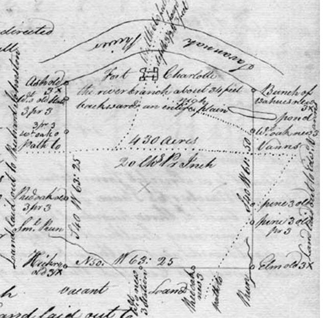
Fig. 45 - Land formerly owned by John Vann on the Savannah
River. [68]
No record exists directly showing John Vann’s
purchase of land in Sout Carolina on the Savannah River. Its location overlooked
his property in Georgia at the confluence of the Savannah and Broad Rivers.
Other patents entered by other individuals confirm that John Vann owned land
there. One example is Richard Johnston’s. Another is for William Cabean. While
the plat for William Cabean no longer exists, his grants and memorials
highlight that both John Vann, and his brother Edward Vann were there. 
Richard Johnson’s plat showing “an old survey commonly
called John Vann’s” on the Savannah River in 1762.
Johnston, Richard, Plat for 250 acres on Savannah River - Date: 10/19/1762[69]
Names indexed: Calhoun, Patrick; Johnston, Richard; Leigh, Egerton; Rogers, William; Vanns, John [northwestward part on old survey commonly called John Vann's ...south part on William Rogers “butting on the Savannah River bounding northwest part on an old survey commonly called John Vanns.]
Grant for William Cabean - 1764[70]
I1, p 692.: William Cabean, 200 acres surveyed 18 Sept. 1758 for Edward Vaun [sic] on Savannah River adj. John Vaun [sic]. 24 Nov 1764. Plat certified 7 Aug. 1764.
Cabean, William, Memorial for 200 Acres on Savannah River, Granville County. - Date: 12/15/1766[71]
Names indexed: Cabean, William; Vaughn [sic], Edward; Vaughn [sic], JohnRecords identifying the land where Fort Charlotte was built in 1765 also explain that the 400 acres of land was once owned by John Vann, and later by Roberty Goudey, presumeably having changed hands because of the lawsuit in 1758. These records also mention Edward Vann as a neighbor. Edward Vann and Richard Johnson were both listed as neighbors again in the memorial later that year.
Bull, Liet. Gov. William, for His Majestys use, Plat Fort Charlotte for 430 Acres on the Savannah River. - Date: 4/10/1765[72]
Names indexed: Bull, William; Calhoun, Patrick; Johnston, Richard; Vann, EdwardNoted on plat: "formerly known by the name Vanns or Goudys then esteemed at 400 acres. but now resurveyed at 430 bounding on the Savannah and northwesterly on Edward Vann. Southeasterly on Richard Johnston." "Path to Vanns" tranverses the plat and crosses the Savannah. Fort Charlotte is marked front and center on the Savannah River in the center of the Plat.
Skottowe, Thomas, Secretary of our Province, Memorial for 430 acres on Savanah River for Fort Charlotte- Date: 9/28/1765[73]
Names Indexed: Johnson, Richard; Skottowe, Thomas; Vann, Edward
False Leads
The man named John Vann in Charleston is not considered to be connected to Trader John Vann. He was a carpenter, when Trader John Vann was well involved in the Indian trading business.Vaun, John, Carpenter of Charles Town, to Peter Bonneau, Planter of Berkley County, Bill of Sale for one Slave Negro Boy named Harry - 4/6/1744[74]
Names Indexed: Bonneau, Peter; Harry (Slave); Vaun, John
Locations: Berkeley County; Charleston
Document Type: Bill of Sale
Topics: Slave Sales; Slaves, Named
Vaun, John to William Hopton and Thomas Smith, Assignment of a Mortgage for Part of Town Lot, No. 93 In Charlestown - 1743-1744[75]
Names
Indexed: Hopton, William; Smith, Thomas; Vaun, John
Locations: Charleston
Document Type: Assignment
Topics: Town Lot Mortgages
Locations: Charleston
Document Type: Assignment
Topics: Town Lot Mortgages
Guichard, Francis and Other French Protestants to John Vann, Lease for 50 Years for Part of Town Lot No. 93 in Charlestown - 1753[76]
Names
Indexed: De Harriette, Benjamin; Faucheraud, Gideon; Guichard, Francis;
Manigault, Gabriel; Martin, Jacob; Mazyck, Isaac; Mazyck, Paul; Neufville,
John; Vann, John
Locations:
Charleston
Document
Type: Lease
Topics:
French Huguenot Church
Another source is not connected to Trader John Vann. It
records a grant showing John Vann receiving 250 acres east of the Saluda River.
This John Vann left his will in Newberry County in 1788, where the land grant
was located.Deed Abstract[77]
July 4, 1755 John Vann (5 persons in family) granted 250 acres between Broad and Saludy Rivers.
Vaun, John Of Ninety Six District, Will Typescript, Newberry County (Mss Will: Estate Record Book A, Page 15) - 6/2/1788[78]
Names
Indexed: Goggan, George; Motes, John; Murdock, William; Vaun, Elizabeth;
Vaun, John; Waldrop, John
Locations: Newberry County; Ninety Six District
Document Type: Will (Typescript)
Locations: Newberry County; Ninety Six District
Document Type: Will (Typescript)

References
Adair, J. (1980). Adair's History of the American
Indians (Samuel Cole Williams ed.). New York: Promontory Press.
Adair, J. (2005). The
History of the American Indians. (K. E. Braund, Ed.) University of
Alabama Press.
Anderson, W. L.
(n.d.). A Guide to Cherokee Documents in Foreign Archives: C.O. 5/455 South
Carolina Journal of Minutes of the Council: Jan, 1745/46 – May 1747.
Atkin, E. (1964). The
Appalachian Indian Frontier--Edmond Atkin Report and Plan of 1755. (W. R.
Jacobs, Ed.) Lincoln: University of Nebraska.
Bartram, W. (n.d.). Travels
in North America. New Haven: Yale University Press.
Bell, J. W. (1999). Chief
James Vann. Hodges, South Carolina: Lindy Publications.
Bell, M. B. (1963). Colonial
Bertie County NC Deed Books A-H 1720-1757. Greenville, SC: Southern
Historical Press.
Brodhead, J. R.
(n.d.). New York Colonial Manuscripts, New York Papers, Gr. No. 71. Documents
Relative to the Colonial History of the State of New-York, 6.
Brown, J. P. (1938). Old
Frontiers. Kingsport, Tennessee: Southern Publishers, Inc.
Butcher, J. B. (1981).
Probate records in Chowan County, N.C. North Carolina: author.
Candler, A. D. (n.d.).
The Colonial Records of the State of Georgia, Volume 7 .
Cann, D. M. (2000). Old
Ninety Six in the South Carolina Backcounty--1700-1781. Eastern National.
Chicken, G. (1916).
The Journal of George Chicken, 1725-1728. In N. D. Mereness (Ed.), Travels
in the American Colonies (p. 132). New York: The McMillan Co.
Commons, H. o. (1750).
The Journal Of The Commons House Of Assembly, 23 APRIL 1750 - 31 AUGUST
1751. (R. N. Olsberg, Ed.) S.C. Dept. of Archives and History.
Commons, S. H. (1745).
The Colonial Records Of South Carolina: The Journal of the Commons House
Of Assembly September 10, 1745 - June 17, 1746 and September 10, 1746 - June
13, 1747.
Corkran, D. H. (1962).
The Cherokee Frontier: Conflict and Survival, 1740–62. Norman:
University of Oklahoma Press.
Crane, V. W. (1928). The
Southern Frontier 1670-1732. Durham, North Carolina: Duke Universty
Press.
Davidson, G. G.
(n.d.). Early Georgia Records: Wilkes County.
Davis, J. R. (Ed.).
(2000). The Wilkes County Papers, 1773-1833. reprint: Southern
Historical Press.
Davis, R. S. (Ed.).
(1983 & 2000). The Wilkes County Papers 1773-1833. Greenville, SC:
Southern Historical Press.
Davis, R. S. (Ed.).
(2000). The Supplement to: The Wilkes County Papers 1773-1889.
Greenville, SC: Southern Historical Press, Inc.
Drayton, J. (1821). Memoirs
of the American Revolution (Vol. 1). Charleston: A. E. Miller.
Dunkerly, R. a.
(2006). Old Ninety Six - A History & Guide. Charleston: The
History Press.
Fernow, B. (Issue 17).
The Ohio Valley in Colonial Days. Munsell's Historical Series.
Fox, G., & Jones,
R. M. (1667). George Fox An Autobiography
(http://www.strecorsoc.org/gfox/title.html ed.).
Gammon, D. B. (n.d.). Records
of Estates, Bertie County, North Carolina, Volume 2, 1734-1788.
Goff, J. H. (1975). Placenames
of Georgia. Atlanta: Arabesque Books.
Goodpasture, A. V.
(1926, vol. 9, no. 4). Early Travels in the Tennessee Country. Tennessee
Historical Magazine, pp. 266-272.
Greene, J. (1978). Ninety
Six - A Historical Narrative Study and Report. Denver: Denver Service
Center, National Park Service.
Hargrett, D. M.
(n.d.). The Hargrett Rare Book and Manuscripts Library. University of
Geogia Library. Athens, Georgia.
Hathaway, J. R.
(1900). The North Carolina Historical and Genealogical Register, Volumes
1-3.
Hatley, T. (1993). The
Dividing Path, Cherokee and South Carolinians through the Era of Revolution.
New York, Oxford: Oxford University Press.
Herbert, J. (1936). Journal
of Colonel John Herbert, Commissioner of Indian Affairs for the Province of
South Carolina, October 17, 1727-March 19th, 1727/8 (A.S. Salley, editor
ed.). Columbia.
Hicks, J. R. (2003). Cherokee
Lineages. Alexandria, VA: author.
Hicks, T. M. (1998). South
Carolina Indian Traders and Other Ethnic Connections beginning in 1670.
Spartanburg: The Reprint Company, Publishers.
Higginbotham, D. E.
(n.d.). The Papers of James Iredell. Retrieved March 11, 2016, from
http://www.archive.org/details/papersofjamesir1976v1ired
Hitz, A. M. (1956,
September). The Earliest Settlements in Wilkes County. The Georgia
Historical Quarterly Vol. 40, No. 3 , pp. 260-280 .
Hoffman, M. M. (1976).
Chowan Precinct, North Carolina Genealogical Abstracts of Deed Books
1696-1723.
Holcomb, B. (1978). Ninety
Six District SC, Journal of the Court of Ordinary, Inventory Bk Will Bk
1781-1786 (1992 ed.). Greenville, SC: Southern Historical Press.
Holcomb, B. (1993). South
Carolina Deed Abstracts 1773-1778. Columbia: SCMAR.
Holcomb, B. (1994). South
Carolina Deed Abstracts 1776-1783. Columbia: SCMAR.
Holcomb, B. (1996). South
Carolina Deed Abstracts 1783-1788. Columbia: SCMAR.
Holcomb, B. (1997). Petitions
for Land from the South Carolina Council Journals Volume II: 1748-1752
(Vol. III). Columbia: SCMAR.
Holcomb, B. (1997). Petitions
for Land From the South Carolina Council Journals Volume IV: 1757-1765
(Vol. IV). Columbia: SCMAR.
Holcomb, B. (2006). South
Carolina's Royal Grants Vol 1 1732-1761. Columbia: SCMAR.
Human-Kirkland, S.
(n.d.). Suzi Human-Kirkland's Family Tree: Information about John Vann.
Retrieved March 11, 2017, from
http://www.genealogy.com/ftm/h/u/m/Suzi-Human/WEBSITE-0001/UHP-0889.html
Hunter, G. (1917).
George Hunter’s Map of the Cherokee Country and the Path thereto in 1730. (A.
J. Salley, Ed.) Bullentin of the Historical Commission of South Carolina,
p. No. 4.
Joyner Library, O.
(n.d.). Digital Collection. East Carolina University.
Julien, C. H. (1950). Ninety
Six - Landmarks of South Carolina's Last Frontier Region. Columbia:
University of South Carolina Press.
Koestler, S. M.
(n.d.). Edward Vann. Retrieved March 11, 2016, from
http://sallysfamilyplace.com/edward-vann/
Langley, C. A. (1983
and 2001). South Carolina Deed Abstracts 1719-1772 Vol III, 1755-1768.
Greenville, SC: Southern Historical Press, Inc.
Langley, C. A. (1983).
South Carolina Deed Abstracts 1719-1772 Vol I. Greenville, SC:
Southern Historical Press.
Langley, C. A. (1983).
South Carolina Deed Abstracts 1719-1772 Vol IV, 1767-1773.
Langley, C. A. (1984).
South Carolina Deed Abstracts 1719-1772 Vol II, 1740-1755. Greenville,
SC: Southern Historical Press, Inc.
McClinton, R. (Ed.).
(n.d.). The Moravian Springplace Mission to the Cherokees Volume II –
1814—1821. Lincoln: Univ of Nebraska.
McClinton, R. (Ed.).
(n.d.). The Moravian Springplace Mission to the Cherokees, Volume 1 –
1805—1813. Univ of Nebraska, Lincoln.
McDowell, J. W. (Ed.).
(1958). Documents Relating to Indian Affairs 1750-1754. Columbia:
South Carolina Records Department.
Meriwether, R. L.
(1940). The Expansion Of South Carolina, 1729-1765. Kingsport: Southern
Publishers.
Mooney, J. (1995). Myths
of the Cherokee. New York: Dover Publications, Inc.
Paulett, R. (n.d.). An
Empire of Small Places: Mapping the Southeastern Anglo-Indian Trade, 1732 .
Potter, D. W. (1982). Source:
Passports of Southeastern Pioneers 1770-1823 (1994 ed.). Baltimore, MD:
Gateway Press, Genealogical Pub. Co.
Robinson, W. S.
(1996). James Glen: From Scottish Provost to Royal Governor of South
Carolina. Westport: Greenwood Press.
Skinner, C. L.
(2009)). Pioneers of the Old Southwest. BiblioLife.
South Carolina Dept of
Archives and History. (n.d.). Online Records Index. Retrieved 2016,
from http://www.archivesindex.sc.gov/
Starr, E. (1921). History
of the Cherokee Indians-Their Legends and Folk Lore. Oklahoma City:
Genealogical Publishing Co., Inc.
State Archives of
North Carolina. (n.d.). North Carolina Land Grant Images and Data.
Retrieved March 11, 2016, from https://nclandgrants.com/
Timberlake, H. (2007).
The Memoirs of Lt. Henry Timberlake: The Story of a Soldier, Adventurer,
and Emissary to the Cherokees, 1756-1765 (Duane King, editor ed.).
Cherokee, NC: Museum of the Cherokee Indian Press.
Vann, E. E. (n.d.). PEARCE/MCDANAL:
Wm Vann entry "History of the Vann Family". Retrieved March 11,
2017, from http://wc.rootsweb.ancestry.com/cgi-bin/igm.cgi?op=GET&db=:1970152&id=I0096
Warren, M. B. (Ed.).
(1988). South Carolina Newspapers The South-Carolina Gazette 1760.
Danielsville, GA: Heritage Papers.
Waters, H. F.-G. (Vol
26). Early History of Georgia and Sir Alexander Cuming's Embassy to the
Cherokees. The New England Historical and Genealogical Register , pp.
260-271.
Williams, S. C.
(1928). Early Travels in Tennessee, 1540-1800. Johnson City, Tn: The
Watauga Press.
Woodward, G. S. (1963). The
Cherokees. Norman and London: University of Oklahoma Press.
[1] Memorial History of Augusta, Georgia : from Its Settlement in 1735
to the ... ,Charles Colcock Jones, Salem Dutcher
[3]
Setting Out to Begin a New World: Colonial Georgia, Edward J. Cashin (ed.),
Savannah: Beehive Press, 1995, pp. 112-114. https://georgiainfo.galileo.usg.edu/thisday/ownwords/01/05/georgia-unprepared-for-war
[4] Colonial Soldiers of the South, 1732-1774, Murtie J.
Clark, 1999
[5] Proceedings and Minutes of the Governor and
Council from October 30, 1754 to March 6, 1759, The Colonial Records of the
State of Georgia, Vol. VII, p 691
[6]
(Atkin, 1964, p. xviii)
[7]
(Hitz, 1956)
[8] (Candler, pp. 722, 902, 905) ..
[9]
Surveyor General, Survey Records, Colonial
Plats and Warrants, RG 3-3-56, Georgia Archives; et. al. https://vault.georgiaarchives.org/digital/collection/p17154coll1/id/951/rec/1
[10]
(Hitz, 1956)
[11]
(South Carolina Dept of Archives and History, n.d.) Series: S213184, Volume: 0008, Page: 00273, Item: 01.
[12]
(South Carolina Dept of Archives and History, n.d.) Series: S213184, Volume: 0018, Page: 00238, Item: 02
[13]
(South Carolina Dept of Archives and History, n.d.) Deed Book T, p. 497.
From the archives.
[14]
The Georgia Historical
Quarterly, Vol.
40, No. 3 (Septembe, 1956), The Earliest Settlements in Wilkes County, Alex
M. Hitz, p262. https://www.jstor.org/stable/40577691?read-now=1&seq=3#page_scan_tab_contents
[15]
Colonial
records of the State of Georgia / compiled ... v.9 1763/66, pp. 255-256, 404.
[16] The Index-Journal,
Greenwood, South Carolina, 25 May
1997, Sunday, p. 4. https://www.newspapers.com/clip/3389015/gouedy_dist_96_sc_colonial_indian/
[17] (Corkran,
1962, pp. 138-140)
[18]
http://www.rootsweb.ancestry.com/~tnpolk2/CDaughertyLetter.htm
[19]
(Paulett, p. 170)
[21] SC
Archives: Series: S136002 Box: 047A Item: 0224A ignore:
000; Judgement Roll 1758 South Carolina
Court of Common Pleas, Box 47A. Dick D. Fox
[23]
(Adair, 1980, pp. 261-265)
[24] Wikipedia, Fort_Loudoun_(Tennessee)
[25] 1) Documents
Relating to South Carolina, Vol 28, pp 208-212, Public Record Office Great
Britain. B.P.R.O. So. Carolina B.T Vol 19 L 40. 2) The Maryland Gazette, (Annapolis, Maryland) 06 Dec
1759, Thu • Page 2; https://www.newspapers.com/clip/1743071/interpreter_john_vann_governor_ellis/
[26] Documents Relating to
South Carolina, Vol 28, pp 208-212, Public Record Office Great Britain. B.P.R.O.
So. Carolina B.T Vol 19 L 40.
[27]
Colonial records of the State
of Georgia / compiled, Franklin Printing
and Publishing Co., 1904, v.8 1759/62, p. 214.
https://catalog.hathitrust.org/Record/000530729.
[28]
Wikipedia, Fort_Loudoun_(Tennessee)
[29]
Research of Dick D. Fox
[30]
Wikipedia, Fort_Loudoun_(Tennessee)
[31]
(Adair, 1980, pp. 261-265)
[33]
http://www.britishmuseum.org/research/collection_online/collection_object_details/
collection_image_gallery.aspx?assetId=782211001&objectId=3239926&partId=1
[34]
The Colonial Records of South Carolina The Journal of
the Commons House of Assembly, October 6, 1757-January 24, 1761,Terry W.
Lipscomb, Editor, South Carolina Department of Archives and History. (Provided
by Steven J. Coker.)
[35] Wikiart, https://www.wikiart.org/en/joshua-reynolds/scyacust-ukah
[38]
Proceedings and Minutes of the Governor and
Council from October 30, 1754 to ..., Georgia, p. 776.
[39]
The Georgia Historical
Quarterly, Vol.
40, No. 3 (September, 1956), The Earliest Settlements in Wilkes County, Alex
M. Hitz, p. 262. https://www.jstor.org/stable/40577691?read-now=1&seq=3#page_scan_tab_contents
[40]
Grace Gillam Davidson, Early Records of Georgia Vol.I Wilkes County, p15. Records
of the Court of Land Commissioners, The Ceded Lands.
[41]
The Earliest Settlements in
Wilkes County, The Georgia Historical Quarterly, Vol.
40, No. 3 (September, 1956), Alex M. Hitz,
p. 264-265.
[42]
(Langley, South Carolina Deed Abstracts 1719-1772 Vol
IV, 1767-1773, 1983, pp. 88, 184) 1) Deed Book O-3, p.
73 -75; 2) Deed Book V-3, Page 202 -204
[43]
(South Carolina Dept of Archives and History, n.d.) Series: S213184 Volume: 0005 Page: 00404 Item: 01
[44]
(Holcomb,
Petitions for Land From the South Carolina Council Journals Volume IV:
1757-1765, 1997)
p. 41
[45]
(Langley, 1983, p. 26)
[46] (South Carolina Dept of Archives and History, n.d.) Series: S213184 Volume: 0008 Page: 00403 Item: 01
[47] (South Carolina Dept of Archives and History, n.d.) Series: L10005 Reel: 0009 Plat: 04973 ignore: 000
[48]
(Langley, 1983, p. 12)
[49] (South Carolina Dept of Archives and History, n.d.) Series: S111001 Volume: 0013 Page: 00490 Item:
001
[50]
(South Carolina Dept of Archives and History, n.d.) Series:
S213184 Volume: 0004 Page: 00268 Item: 00
[51]
(South Carolina Dept of Archives and History, n.d.) Series:
S213184 Volume: 0004 Page: 00268 Item: 00
[52]
(South Carolina Dept of Archives and History, n.d.) Series: S111001 Volume: 0008 Page: 00241 Item: 002
[53] (Holcomb, South Carolina Deed Abstracts 1783-1788, 1996, p. 336)
[54]
(South Carolina Dept of Archives and History, n.d.)
Series: S213184 Volume: 0007 Page: 00181 Item: 02
[55]
(South Carolina Dept of Archives and History, n.d.)
Series: S213184 Volume: 0007 Page: 00215 Item: 01
[56]
(South Carolina Dept of Archives and History, n.d.) Series:
S213184 Volume: 0007 Page: 00329 Item: 02
[57]
(South Carolina Dept of Archives and History, n.d.) Series:
S213019 Volume: 0011 Page: 00279 Item: 000
[58]
(South Carolina Dept of Archives and History, n.d.) Series: S213184
Volume: 0005 Page: 00431 Item: 01
[59]
(South Carolina Dept of Archives and History, n.d.) Series: S213184
Volume: 0019 Page: 00074 Item: 02
[61]
(South Carolina Dept of Archives and History, n.d.) Series: S213184 Volume:
0019 Page: 00188 Item: 03
[62]
(South Carolina Dept of Archives and History, n.d.) Series:
S111001 Volume: 0011 Page: 00080 Item: 002
[63]
(Holcomb, Petitions for Land from the South Carolina Council Journals
Volume II: 1748-1752, 1997, p. 208)
[64] (South Carolina Dept of Archives and History, n.d.) Series: S213184 Volume:
0006 Page: 00375 Item: 04
[65]
(Holcomb, Petitions for Land From the
South Carolina Council Journals Volume IV: 1757-1765, 1997, p. 31)
[66] (South Carolina Dept of Archives and History, n.d.) Series: S213019 Volume:
0009 Page: 00073 Item: 000
[67]
(Holcomb, South Carolina Deed Abstracts 1783-1788, 1996) pp. 334, 216.
[68]
(South Carolina Dept of Archives and History, n.d.) Series: S213184, ,
Volume: 0008, Page: 00007, Item: 02
[69] (South Carolina Dept of Archives and History, n.d.) Series: S213184,
Volume: 0008, Page: 00535, Item: 02.
[70]
South Carolina’s Royal Grants,Vol. Two, Brent Holcomb, SCMAR, Colombia, 2007,
p. 89.
[71]
(South Carolina Dept of Archives and History, n.d.) Series: S111001, Volume: 0006, Page: 00355, Item: 003.
[72]
(South Carolina Dept of Archives and History, n.d.) Series: S213184, ,
Volume: 0008, Page: 00007, Item: 02
[73] (South Carolina Dept of Archives and History, n.d.) Series: S111001, Volume: 0008, Page: 00099, Item:
004.
[74]
(South Carolina Dept of Archives and History, n.d.) Series: S213003,
Volume: 002F, Page: 00064,
Item: 000
[75]
(South Carolina Dept of Archives and History, n.d.) Series: S372001,
Volume: 00Z0, Page: 00466,
Item: 000
[76]
(South Carolina Dept of Archives and History, n.d.) Series:
S372001, Volume: 02N0, Page: 00389, Item: 000
[77] (Holcomb, Petitions for Land From the South Carolina
Council Journals Volume IV: 1757-1765, 1997, p. 169 )
[78]
(South Carolina Dept of Archives and History, n.d.)
Series: S108093, Reel: 0018, Frame: 00459, Item: 000